-
 Jeff Miner
20The California Radon Program has apparently been spending their EPA SIRG (State Indoor Radon Grant) money on the California Geologic Survey Radon Maps. And what a beauty they have produced!
Jeff Miner
20The California Radon Program has apparently been spending their EPA SIRG (State Indoor Radon Grant) money on the California Geologic Survey Radon Maps. And what a beauty they have produced!
You can view radon risk from geologic formations almost down to the street level. Not all of the state is covered yet but the coastal areas and Lake Tahoe where I'm from have detailed radon risk maps.
Give it a try at:
https://maps.conservation.ca.gov/cgs/radon/
I'm curious if other state radon programs have worked with their State Geological Survey Office using GIS data bases to develop similar detailed interactive maps.
I wouldn't expect the EPA to re-do their inaccurate and outdated state radon maps anytime soon, but they should at least link to the more accurate state maps where they exist.
Compare this new interactive state map to the old one the EPA links to:
https://www.epa.gov/radon/state-maps-radon-zones
These 30 (or is it 40?) year old maps are still considered accurate radon risk assessments by groups such as realtors when completing the California Natural Hazard report for real estate transactions. South Lake Tahoe is considered a "Moderate" radon risk using the old maps which are based on an average risk for all of El Dorado County, while the new interactive map clearly shows the Tahoe area, in the Sierra Nevada Mountains with its granitic rock base, as a "High" radon risk area. -
 Bill Brodhead
44Jeff. When you click the link it shows the entire state.
Bill Brodhead
44Jeff. When you click the link it shows the entire state.
Are the only areas of concern the black outlined boxes with the green to red coloring? The rest of the state has no -
 ReveAnn Ellrott
13I have been including this map in my client reports for several years now. The areas in black are the areas that Ron Churchill of CGS had completed radon potential maps combining geology with available indoor radon data. The natural hazard disclosures in Southern California have finally transitioned away from EPA map to this map. I have been mapping indoor radon data in Los Angeles County for 30 years and when overlayed in GIS it is an amazing fit.
ReveAnn Ellrott
13I have been including this map in my client reports for several years now. The areas in black are the areas that Ron Churchill of CGS had completed radon potential maps combining geology with available indoor radon data. The natural hazard disclosures in Southern California have finally transitioned away from EPA map to this map. I have been mapping indoor radon data in Los Angeles County for 30 years and when overlayed in GIS it is an amazing fit. -
 Larainne Koehler
27While radon maps can be useful tools, they can be a double edged sword. How areas are labeled is critical. Areas labeled 'low' give the impression that there is no need to test.
Larainne Koehler
27While radon maps can be useful tools, they can be a double edged sword. How areas are labeled is critical. Areas labeled 'low' give the impression that there is no need to test.
Radon is one of the highest environmental carcinogen risks. In a State where citizens have passed a carcinogen warning statute (Prop 65), it seems inappropriate to have a 'low' rating on anything related to radon as there is still substantial risk below 4pCi/l and it is definitely a carcinogen.
Particularly in areas with high population density, even in a 'low' area, there could be more homes greater than 4 pCi/l than in some states where the whole states are considered 'high'. So the population risk may not be 'low', but people believe there is no need for action .
The CA map does not seem to have any indication that only outlined areas have been mapped -which is also very misleading for someone not familiar with the background. -
ReveAnn Ellrott
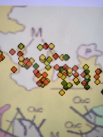
13You make very good points Larainne and one we have been battling for years, especially in California where perceived risk is very low. There is a strong need for additional mapping and data sharing. The CGS interactive map does have a legend that identifies unsurveyed areas but the average citizen wouldn't find it. I agree the word low shouldn't be used. The hazard disclosure here does elaborate low means 6% of homes in a low area are expected to be elevated. In my report I change the wording to lower and add the usual variables such as foundation type which increase risk. The CGS map does miss some areas where risk based on geology is categorized as low but where the growing number of basement homes has increased that risk. To combat that and grow local awareness, I follow the CGS map with my own data that provides more insight into their neighborhood and helps educate realtors. The example below would be a "low" risk area where the number of basement homes is increasing. Red is = >4 and yellow is > 2.7. As you see, this neighborhood should be categorized high risk for homes without a well ventilated foundation. We are noticing a trend to mitigate levels over the WHO recommendation of 2.7. Is anyone else seeing this also?
n0bmzwo309.jpg -
 Stan Plowden
3My experience over 20 years is that radon maps are like a "light posts". They should be used for "illumination" NOT "support!" Consequently, I prefer to tell everyone that EVERY structure has radon! But the ONLY way you will know "how much" is to TEST! I would argue this eliminates all the "speculation" about whether a house is in a Zone 1, 2 or 3 county. As mitigators, most of us have probably installed systems in Zone 2 and 3 homes that came back at "double digits". NO home has a problem with radon until it's tested! And homes constructed by builders with passive piping need NEVER be tested, right? (haha). I'd be interested to see a stat that showed how many homes out of a 100 with fans installed on the pipes STILL came back HIGH? :scream:
Stan Plowden
3My experience over 20 years is that radon maps are like a "light posts". They should be used for "illumination" NOT "support!" Consequently, I prefer to tell everyone that EVERY structure has radon! But the ONLY way you will know "how much" is to TEST! I would argue this eliminates all the "speculation" about whether a house is in a Zone 1, 2 or 3 county. As mitigators, most of us have probably installed systems in Zone 2 and 3 homes that came back at "double digits". NO home has a problem with radon until it's tested! And homes constructed by builders with passive piping need NEVER be tested, right? (haha). I'd be interested to see a stat that showed how many homes out of a 100 with fans installed on the pipes STILL came back HIGH? :scream: -
 Chris Bonniwell
1Another useful tool out there is the compilation of pre-mitigation indoor air testing data that the CDC has collected. It can be illustrated by county as the median, mean, or maximum Radon concentrations. It is particularly interesting to look at side by side maps showing the mean concentrations and the maximum concentrations. FOr example, the average for the San Diego area is 0.9 pCi/l, but the maximum measured is 45.2 pCi/L. Even a "low risk" area can be a concern. Only way to know is to test.
Chris Bonniwell
1Another useful tool out there is the compilation of pre-mitigation indoor air testing data that the CDC has collected. It can be illustrated by county as the median, mean, or maximum Radon concentrations. It is particularly interesting to look at side by side maps showing the mean concentrations and the maximum concentrations. FOr example, the average for the San Diego area is 0.9 pCi/l, but the maximum measured is 45.2 pCi/L. Even a "low risk" area can be a concern. Only way to know is to test.
https://ephtracking.cdc.gov/DataExplorer/ -
ReveAnn Ellrott
13Thank you for sharing the resource Chris--very informative and a great tool for researchers and techs alike
-
Jeff Miner
20Bill Brodhead, the map takes a little getting used to. The symbols in the upper right give a lot of info about the map and how to use it.
ReveAnn Ellrott, I am so glad to learn that the map is being used in California and that the Natural Hazard Disclosure report in Southern California is using it. I wonder if ALL providers of NHD reports are using it. The fact that the map is front and center when you go to the California Radon Program web page is good sign that more people will become aware of it.
Larainne Koehler, good point that we should not only rely on radon maps but we should test all houses. However, like it or not, many people and institutions do rely on quick visual content, maps included, rather than reading the fine print to make a determination. Look at the widespread use of the of the original EPA state and county radon maps, accurate or not. As the science of geology and GIS database mapping continues to evolve, there is no reason I can see not to provide the best possible radon maps to the public. Of course "test every home" can be the gold standard recommendation, but these GIS maps will become more common and it gives people a chance to see the latest science on radon risk from a geologist's standpoint. I'm all for them.
Stan Plowden, I agree that there are high radon homes in low risk areas. Testing every home is still our radon awareness goal. However we have not been very good at delivering on that goal. I read that on the 50th anniversary of the EPA they estimated that 2 million families have tested and fixed their homes in the last 30 years of radon SIRG grants. Compare that to 128 million households in the U.S. and you get less than 2% of homes mitigated in 30 years. I'm unimpressed with the "progress" of testing every home.
Chris Bonniwell, that CDC National Environmental Public Health Tracking Network map was great! You can ask about testing multiple ways. One sad thing I learned, for California anyway, is that while the large testing companies turn in testing data to the CDC on a regular basis, my California Radon Program has not turned over any testing data since 2016. While I am happy with the progress on the radon maps, I must say I am frustrated that the California Radon Program only employs one very part-time employee who is not given the resources to ask the smaller radon measurement companies to send her their test results, much less to do any radon awareness outreach. Our Radon Test Data Base by zip Code (https://www.cdph.ca.gov/Programs/CEH/DRSEM/CDPH%20Document%20Library/EMB/Radon/Radon%20Test%20Results.pdf) is only updated to 2016 and more than that it is not in a format that can be easily charted or graphed. I had to translate it over to Excel to do any decent analysis and charts by zip codes. -
Larainne Koehler
27Jeff,
We can all certainly wish that our radon programs had been more effective, but we should be looking at the meaningful numbers to assess our progress. Every household in the US does not need to be mitigated, therefore your less than 2% estimate is irrelevant.
For example:
There have certainly been more than 2 million homes tested in the US - NJ had 1.185 million homes tested between 1996 and 2019 which is 35% of their homes. Of the homes tested, 180,000 tested over 4 pCi/l and 48.5% of those homes have been mitigated. The State has made regular progress towards its Healthy People 2020 Goal of getting 50% of the homes over 4 mitigated. This has also been an ongoing progress point for their SIRG grants. These numbers are not estimates, but are based on reported information from their certified testers and mitigators.
https://www-doh.state.nj.us/doh-shad/indicator/view/Radon.Year.html
https://www-doh.state.nj.us/doh-shad/indicator/view/RadonMitigation.Year.html -
 Gloria Linnertz
11The only way to know if elevated levels of radon is present is to test. That is why every home, workplace, and school should be tested. Of course, education and awareness is needed before people realize the danger of radon exposure.
Gloria Linnertz
11The only way to know if elevated levels of radon is present is to test. That is why every home, workplace, and school should be tested. Of course, education and awareness is needed before people realize the danger of radon exposure. -
Jeff Miner
20Larainne,
Of course you are right, we have made progress. But as I look around here in California I see unmet resistance from the real estate industry, the construction industry, the legislature, and even the California Radon Program that fuels my pessimism. Are there better approaches to getting RRNC into all new construction? Getting required radon tests with every real estate transaction? Getting the California Department of Public Health to fund a full person to run the radon program in the most populous state? Getting the California legislature to require that the Natural Hazard Report to use current and local radon maps? Are there better, more effective ways to forward our agenda? Sorry for the venting. -
 Robert Burns
31The EPA map, created in 1993 and that I don't believe has changed since I started in 1990, clearly shows western South Dakota as zones 2 or 3. There is nothing on that map that tells a new viewer what those numbers mean and maybe that is a good thing since the area is not low to moderate. Western SD is the home to historic and current uranium mining. I have seen levels above 1,000 pCi/l and urban areas where every home is triple digits.
Robert Burns
31The EPA map, created in 1993 and that I don't believe has changed since I started in 1990, clearly shows western South Dakota as zones 2 or 3. There is nothing on that map that tells a new viewer what those numbers mean and maybe that is a good thing since the area is not low to moderate. Western SD is the home to historic and current uranium mining. I have seen levels above 1,000 pCi/l and urban areas where every home is triple digits.
Experienced builders install active systems during construction because they have had sales fall through when a high test comes in not because they looked at the EPA map.
I helped a home owner attempt to mitigate his home that was above 500 pCi/l. The owner was going to install a passive system during construction but changed his mind when he looked at the EPA map. He has got it down below 10 and has decided to live with that since the next steps are both expensive and unattractive.
The USGS maps clearly show the risk is high and 30 years of testing have proved that fact yet the EPA map remains unchanged and inaccurate. It should be removed from the website. I believe people looking at the map use it as a reason for inaction. Even if it was updated to perfectly match the USGS maps it would not accurately reflect the surface geology that can vary from lot to lot in a subdivision.
https://www.epa.gov/sites/default/files/2015-07/documents/zonemapcolor.pdf


Welcome to the Radon ListServ!
Join Radon ListServ Categories that pique your interests and area of expertise.
More Discussions
- Terms of Service
- Useful Hints and Tips
- Sign In
- © 2026 Radon ListServ